
Introduction
The River Beauly drains a catchment of approximately 1000 square kilometres of land thus making it the second largest catchment north of the Great Glen. The catchment extends almost to the west coast with the most westerly tributaries being only approximately 7km east of Loch Duich. For management purposes the district can be sub-divided into five management units.
Beauly Management Units
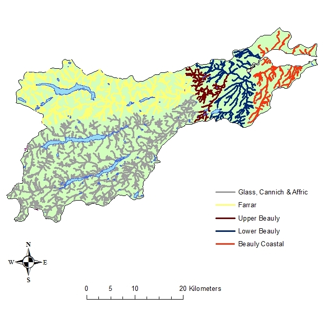
Some features of this map are based on digital spatial data licensed from the Centre for Ecology and Hydrology, © CEH. Includes material based on Ordnance Survey 1:50,000 maps with the permission of the controller of Her Majesty’s Stationery Office © Crown copyright.
The management units utilised for the Beauly Fisheries Management Plan are:
- Beauly Coastal
- Lower Beauly
- Upper Beauly
- Farrar
- Glass, Cannich & Affric
Topography
The mean altitude of the catchment is in excess of 385m and several peaks are in excess of 1000m. Steeper gradients and therefore higher flow velocities are typically found in the upper parts of the catchment.
Geology
The Mullardoch and Affric regions of the upper catchment comprise largely of metamorphosed sedimentary rocks belonging to the Moine succession. Around Loch Monar there are outcrops of older metamorphic rocks. Strathglass is dominated by quartz-feldspar-granulite. The Farrar catchment contains quartz-feldspar-granulite, schists and gneiss. The lower catchment is dominated by Old Red Sandstone.
Beauly District Bedrock Geology
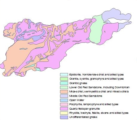 Bedrock data, Digital Geological Map of Great Britain 1:625 000 (DiGMapGB-625), British Geological Survey (2003), © and database right NERC.
Beauly District Superficial Geology
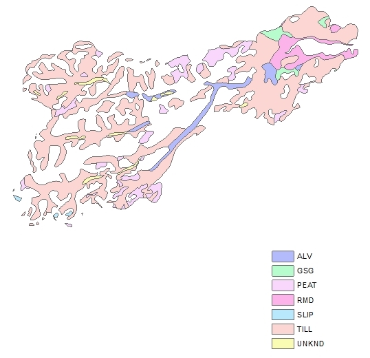 Superficial Deposits data, Digital Geological Map of Great Britain 1:625,000 (DiGMapGB-625), British Geological Survey (2003), © and database right NERC
Key to Superficial Geology:
ALV = Alluvium
GSG = Glacial Sand and Gravel
Peat = Peat
RMD = Raised Marine Deposits
Slip = Landslip
Till = Till
UNKD = Unknown
Climate
Given the large geographical area covered by the catchment it may be anticipated there is a widespread variation in climatic conditions. Examination of Met Office 1971-2000 data indicates that the area of the Beauly catchment closest to the Moray Firth has a mean temperature of 7.5-8.5°C, annual rainfall of 500-1200mm and 1100-1200 hours of sunshine per annum. This contrasts with an average mean temperature of 1-5°C, annual rainfall of 2800-4400mm and 750-950 hours of sunshine in the westerly extremes of the catchment.
Hydrology
The National Rivers Flow Archive contains details of historical flow data at several locations within the Beauly system. SEPA gauging stations currently operate at Erchless (River Glass), Struy (River Farrar) and Red Bridge (River Beauly).
Water Quality
Examination of SEPAs classifications for the Beauly catchment suggests that water quality is generally of a high standard. Pollution incidents, however, do occur on occasion and NBFT and BDFB remain vigilant in respect of maintaining high water quality standards. Diffuse pollution may also be an issue in some agricultural areas of the catchment.
Land Use
Land use within the Beauly is broadly similar to neighbouring catchments with large areas owned by sporting estates and forestry enterprises (often utilised for deer stalking), rough grazing for cattle and sheep and both commercial timber forestry and native woodland. The largest urban conurbation is Beauly, located in the lower reaches of the River Beauly system. Glen Affric contains the third largest remnant of the Caledonian Forest and has been designated as a National Nature Reserve.
Land use in the Beauly catchment

Land Cover of Scotland data, 1:25,000, MLURI 1993