
Introduction
The Ness catchment is the largest in the North Highlands and drains approximately 2000 square kilometres of land. The upper reaches of the Ness catchment extend almost to the west coast close to Loch Hourn and Loch Nevis. The land drains East & North through the Great Glen before entering the sea in the Moray Firth at Inverness. For management purposes the district can be sub-divided into seven management units.
Ness District Management Units
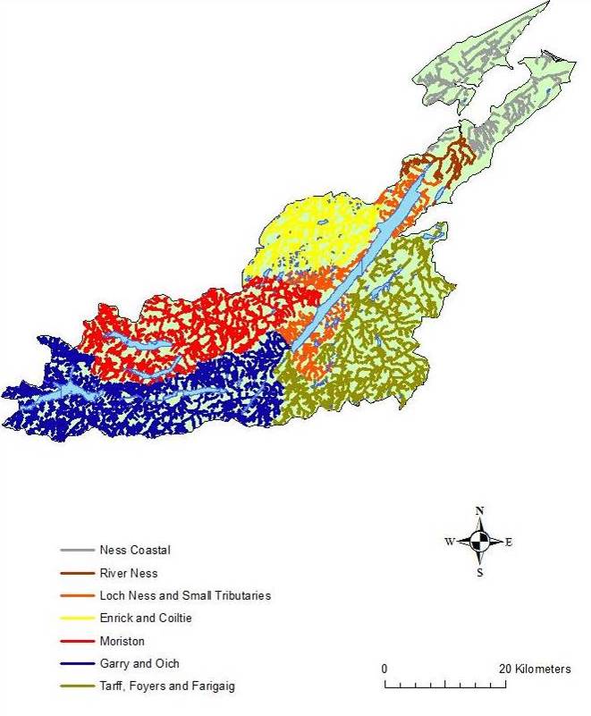
Some features of this map are based on digital spatial data licensed from the Centre for Ecology and Hydrology, © CEH. Includes material based on Ordnance Survey 1:50,000 maps with the permission of the controller of Her Majesty’s Stationery Office © Crown copyright.
Each of these management units is described in further detail below:
- Ness Coastal – Inverness Firth and smaller coastal burns, particularly important for sea trout but also salmon
- River Ness The main River Ness with its water temperature kept artificially high by Loch Ness and as such it has no temperature barrier. This unit also incorporates the key tributaries of the main river, including the Holm Burn and Allt na Skiach;
- Loch Ness and Small Tributaries – The famous Loch extending 37km and its smaller tributaries, the mouths of which are important spawning areas for salmon, trout and Arctic charr;
- Rivers Enrick and Coiltie – Flowing into Urquhart Bay and supporting one of only a few alluvial woods remaining in the United Kingdom. Also thought to be important spawning areas for summer and autumn salmon and grilse;
- River Moriston – Designated as a Special Area of Conservation (SAC) for freshwater pearl mussel and Atlantic salmon. It supports an important ‘spring’ salmon fishery and is heavily impacted by large scale hydroelectric schemes;
- Rivers Garry and Oich – Separated by Loch Oich. The River Oich runs parallel to the Caledonian Canal with extensive modifications being made to the river during its construction. Both the Garry and the Oich support important ‘spring’ salmon fisheries and are heavily impacted by large scale hydroelectric schemes; and
- Rivers Tarff, Foyers and Farigaig – All support salmon populations to a greater or lesser degree and form important juvenile and nursery areas. They are however less important in terms of angling. The Tarff and Foyers are impacted by Hydroelectric schemes.
Topography
The rivers draining from the north of the Great Glen Rift Fault tend to be less steep in nature than those flowing from south of the fault. The highest altitude areas in the Ness catchment are to the north of Loch Quoich (Garry sub-catchment) and Loch Cluanie (Moriston sub-catchment) with some peaks in excess of 900m.
Geology
A description of the geology of the ness catchment can broadly be split into two, namely those areas north and those areas south of the Great Glen Fault. To the north the rocks are largely Monian in nature consisting of granulites, schists and gneisses. However, there are also substantial areas of Old Red Sandstone, particularly between Invermoriston and Urquhart Bay and on the south shore of Loch Ness. To the south bedrock geology is dominated by large granatic intrusions and Monian rocks. The River Ness area is dominated by Old Red Sandstone.
The rivers draining from the north of the Great Glen Rift Fault tend to be less steep in nature than those flowing from south of the fault. The highest altitude areas in the Ness catchment are to the north of Loch Quoich (Garry sub-catchment) and Loch Cluanie (Moriston sub-catchment) with some peaks in excess of 900m.
In addition to the above the Caledonian Canal intersects the Ness system at various points. The canal runs some 60 miles (97 km) from northeast to southwest. Only one third of the entire length is man-made, the rest being formed by Loch Dochfour, Loch Ness, Loch Oich and Loch Lochy (in the neighbouring catchment).
Ness District Bedrock Geology
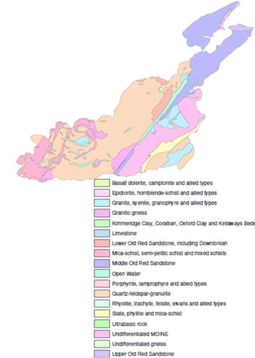
Bedrock data, Digital Geological Map of Great Britain 1:625 000 (DiGMapGB-625), British Geological Survey (2003), © and database right NERC.
The soils found along the River Ness valley are predominately humus iron podzols with some gleys suitable for arable and permanent pasture. The upland areas of the catchment give rise to run-off with a low mineral and high organic content. Such areas tend to have higher acidity compared to area draining sandstone, for example.
Ness District Superficial Geology
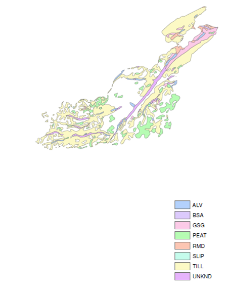
Bedrock data, Digital Geological Map of Great Britain 1:625 000 (DiGMapGB-625), British Geological Survey (2003), © and database right NERC.
Climate
Given the large geographical area covered by the catchment, there is widespread variation in climatic conditions. Examination of Met Office 1971 to 2000 data indicates that the area of the Ness catchment closest to the Moray Firth has a mean temperature of 8.5 to 9.5oC, annual rainfall of 500 to 1200mm and 1100 to 1200 hours of sunshine per annum. This contrasts with an average mean temperature of 1 to 5oC, annual rainfall of 2800 to 4400mm and 750 to 950 hours of sunshine in the upland extremes of the catchment.
Hydrology and Water Quality
The table below represents a summary of data currently available from the National River Flow Archive. It should be noted that all river flows listed, with the exception of the Enrick and Coiltie are altered to a greater or lesser extent by hydro-electric regulation. Water quality within the catchment would appear largely to be good.
River Flow Archive Data
|
Station |
Average Flow (m3s-1) | Q95 (m3s-1) |
| Ness-Side (River Ness) | 90.18 | 19.87 |
| Ardachy Bridge (River Tarff) | Not currently available | Not currently available |
| Craigard (River Garry) | Not currently available | Not currently available |
| Levishie (River Moriston) | 5.853 | 0.713 |
| Mill of Tore (River Enrick) | 3.26 | 0.072 |
| White Bridge (River Enrick) | Not currently available | Not currently available |
| Ivy Bridge (River Coiltie) | Not currently available |
Not currently available |
Land Use
Land use within the Ness catchment is dominated by sporting estates (mostly deer stalking), rough grazing for cattle and sheep and both commercial timber forestry and native woodland. Arable agriculture is restricted largely to the lowland areas and in particular the coastal region.
Land use in the Ness catchment
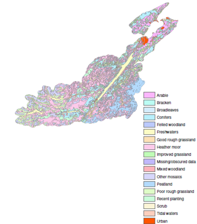
Land Cover of Scotland data, 1:25,000, MLURI 1993
Major urban conurbations such as Inverness are found largely in the coastal district. Other settlements tend to be relatively small in nature and are usually located in the lower reaches of rivers e.g. Fort Augustus, Invergarry and Drumnadrochit.
The catchment contains large tracts of forestry including areas utilising commercial species and areas of species with a high conservation value (e.g. alluvial alder in Glen Urquhart Bay). Ownership of forestry areas is diverse and includes both the public and private sector. Indications from Forestry Commission Scotland suggest that some areas utilised for commercial tree species e.g. sitka spruce may well be planted with native species once the current harvesting cycle has been completed.
The Ness catchment has been the subject of extensive hydro-electric schemes, a process which began with a small scheme in Fort Augustus in c1890 and which is continuing to the present day with the completion of the Glen Doe scheme. Several new smaller micro-hydro schemes are under construction. Of particular importance in respect of the salmon populations of the Ness system are the effects of the Glen Garry and Glen Moriston schemes. Overall, hydro-electric development either directly or indirectly affects a considerable proportion of the Ness catchment.